You are using an out of date browser. It may not display this or other websites correctly.
You should upgrade or use an alternative browser.
You should upgrade or use an alternative browser.
Campus Updates
- Thread starter OriginalAdmiral
- Start date
- Latest activity Latest activity:
This pic from 1951 shows the area the campus would eventually be built on. I never knew a large portion of the land was already cleared until now.
Deacfreak07
Ain't played nobody, PAWL!
It's always crazy to me how significant a construction undertaking building what still amounts to most of campus from scratch all in one big project.
Deacfreak07
Ain't played nobody, PAWL!
This pic from 1951 shows the area the campus would eventually be built on. I never knew a large portion of the land was already cleared until now.
I'm assuming that's bascially Robin Hood Rd. with Graylyn on the left, Reynolda on the right, & Lake Katherine in the middle? Or is that Graylyn?
I'm assuming that's bascially Robin Hood Rd. with Graylyn on the left, Reynolda on the right, & Lake Katherine in the middle? Or is that Graylyn?
If my bearing are right, Graylyn should be just out of the picture on the bottom left. Best I can tell, its an aerial shot from what is now the area near the Reynolda Rd and Coliseum Drive intersection.
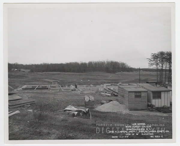
Carswell, and the field where the athletic practice buildings and fields are now.
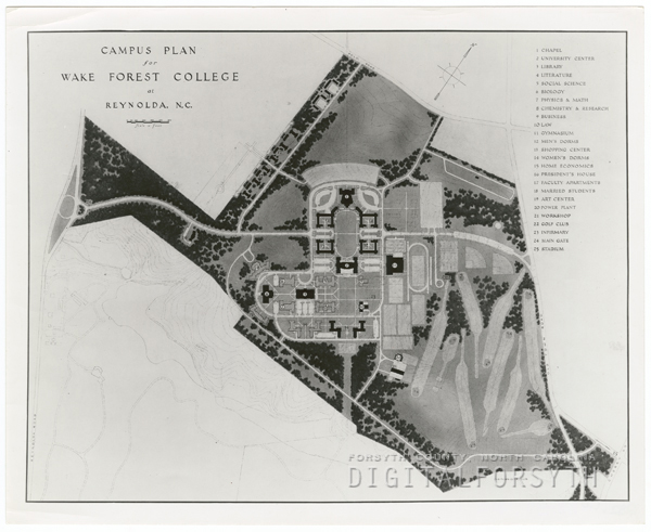
The initial campus plan. Its a shame you cant zoom in closer.
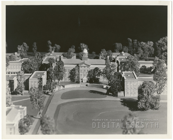
Small scale campus model, pre-construction.
The initial campus plan. Its a shame you cant zoom in closer.
Small scale campus model, pre-construction.
Deacfreak07
Ain't played nobody, PAWL!
If my bearing are right, Graylyn should be just out of the picture on the bottom left. Best I can tell, its an aerial shot from what is now the area near the Reynolda Rd and Coliseum Drive intersection.
That makes more sense. What is that building on the left? Part of Reynolda Village?
Deacfreak07
Ain't played nobody, PAWL!
Carswell, and the field where the athletic practice buildings and fields are now.
The initial campus plan. Its a shame you cant zoom in closer.
Small scale campus model, pre-construction.
I wonder if anyone has that small scale model? I would love a framed print of the original plan. It's a shame the golf course never happened.
That makes more sense. What is that building on the left? Part of Reynolda Village?
I could be wrong, but it looks like a very large barn.
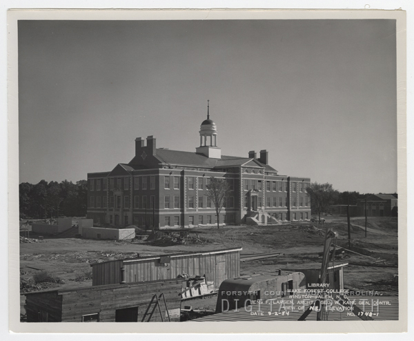
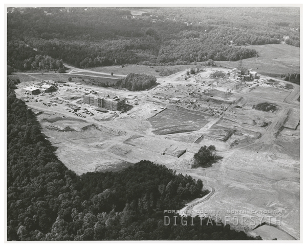
Aerial of Wake Forest College under construction. Wait Chapel is at right, with the Z. Smith Reynolds Library at left.
That makes more sense. What is that building on the left? Part of Reynolda Village?
I could be wrong, but it looks like a very large barn.
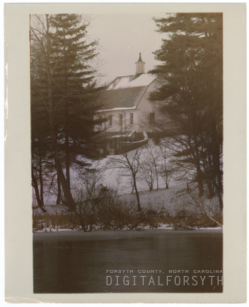
View of Reynolda House ground in snow, with Lake Katherine in foreground, barn in background.
I'm really digging these aerial photos.
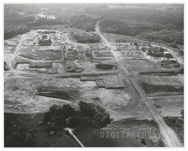
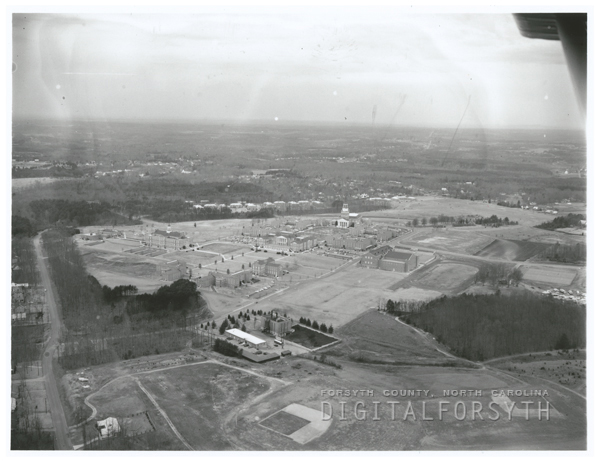
Aerial of Wake Forest College under construction. Wait Chapel is at right, and the Z. Smith Reynolds Library is at left.
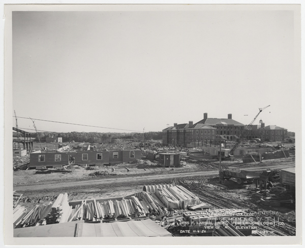
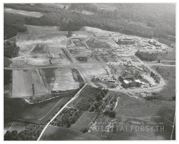
Aerial of Wake Forest College under construction. Wait Chapel is located near the bottom, to the right of center. The Z. Smith Reynolds Library is near the top, right of center.
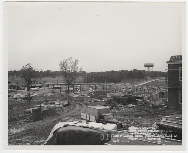
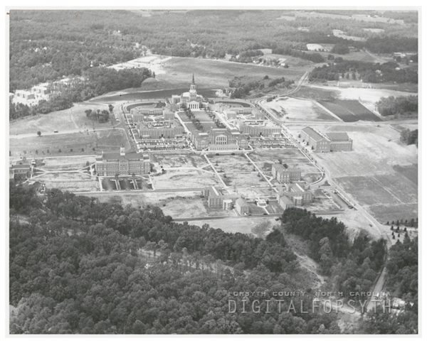
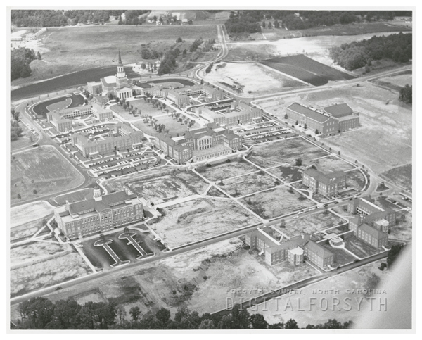
Aerial of Wake Forest College under construction, 1956. Wait Chapel is near the top at left, with many other buildings already completed.
Aerial of Wake Forest College under construction. Wait Chapel is at right, and the Z. Smith Reynolds Library is at left.
Aerial of Wake Forest College under construction. Wait Chapel is located near the bottom, to the right of center. The Z. Smith Reynolds Library is near the top, right of center.
Aerial of Wake Forest College under construction, 1956. Wait Chapel is near the top at left, with many other buildings already completed.
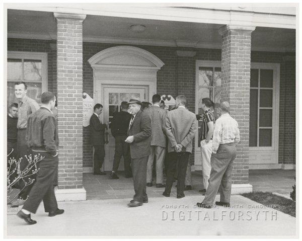
Onlookers after a robbery of the Wachovia branch at Wake Forest College campus, 1958.
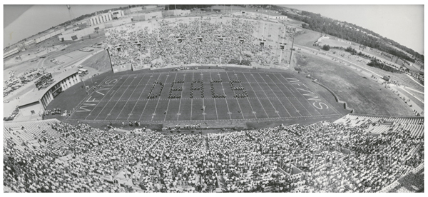
Panorama of Groves Stadium during a football game between Wake Forest and Clemson, 1968. The background buildings at left and center belong to R. J. Reynolds Tobacco Company. Ernie Shore Field is at right.
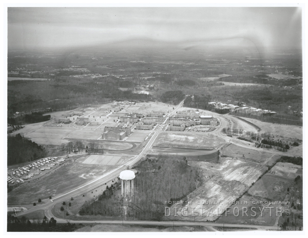
Aerial of Wake Forest College campus, 1959. The water tower can be seen at the bottom center. The street at the bottom is University Parkway.
Aerial of Wake Forest College campus, 1959. Faculty Drive can be seen at the far left of the photo, with the baseball fields at the bottom.
Panorama of Groves Stadium during a football game between Wake Forest and Clemson, 1968. The background buildings at left and center belong to R. J. Reynolds Tobacco Company. Ernie Shore Field is at right.
Aerial of Wake Forest College campus, 1959. The water tower can be seen at the bottom center. The street at the bottom is University Parkway.
Aerial of Wake Forest College campus, 1959. Faculty Drive can be seen at the far left of the photo, with the baseball fields at the bottom.
I went back and searched for pics from the 1940s-1950s.
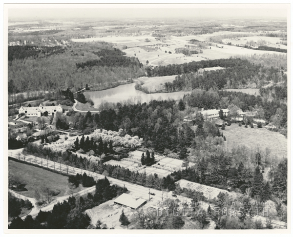
Aerial of the Reynolda Estate, Reynolda Road, and the site where Wake Forest College was built. Reynolda House can be seen at right, with Lake Katherine behind the house. Reynolda Gardens are near the bottom of the photo, near Reynolda Road.
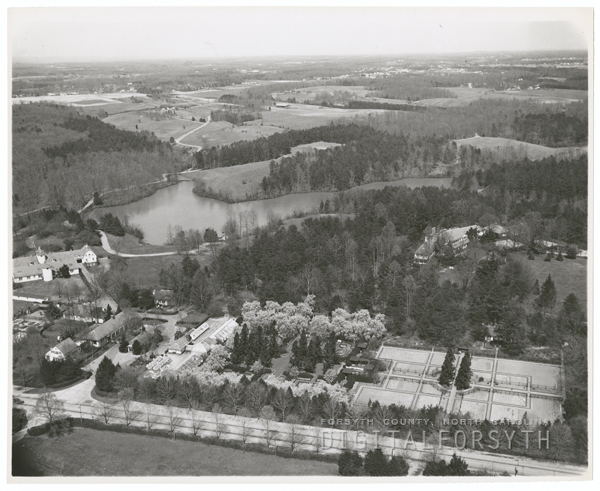
Aerial of the Reynolda Estate, Reynolda Road, and the site where Wake Forest College was built. Reynolda House can be seen at right, with Lake Katherine behind the house. Reynolda Gardens are near the bottom of the photo, near Reynolda Road.
HailToTheDeacons
Fantasy Sheep Champion
- Joined
- Mar 15, 2011
- Messages
- 29,347
- Reaction score
- 2,186
I could be wrong, but it looks like a very large barn.
Is that where Silo is now?
HailToTheDeacons
Fantasy Sheep Champion
- Joined
- Mar 15, 2011
- Messages
- 29,347
- Reaction score
- 2,186
Panorama of Groves Stadium during a football game between Wake Forest and Clemson, 1968. The background buildings at left and center belong to R. J. Reynolds Tobacco Company. Ernie Shore Field is at right.
Interesting 'WF/WS' in the endzones.
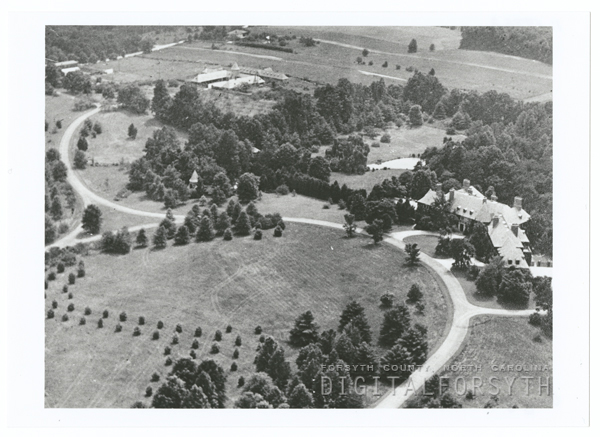
Aerial of the Graylyn estate, located off of Reynolda Road. The Graylyn estate was the home of the Bowman Gray family.
HailToTheDeacons
Fantasy Sheep Champion
- Joined
- Mar 15, 2011
- Messages
- 29,347
- Reaction score
- 2,186
Aerial of the Reynolda Estate, Reynolda Road, and the site where Wake Forest College was built. Reynolda House can be seen at right, with Lake Katherine behind the house. Reynolda Gardens are near the bottom of the photo, near Reynolda Road.
It looks like Reynolda Gardens was even more intentional with landscape architecture back then.
Yeah, looking at google maps, is where the Silo deli is now. Its the old cattle barn.Is that where Silo is now?